Today, I am focusing on the Cairngorms which is the highest
massif in Britain and located in north central Scotland. The Cairngorm
Mountains consist of a series of peaks and ridges which reach altitudes
of up to 4,300 feet (1290 m). The rock is granite. The mountains
comprise two contrasting landscapes: smooth, rounded summit areas and
deep troughs and corries. The massif constitutes the most extensive area
over 3000 feet in Scotland.
Video clip taken from the Mountain Railway
Snow-Capped Cairngorm Mountains viewed from Aviemore
The coincidence of landform and climate has given rise to ideal
skiing conditions.The high elevation results in extensive snowfall which
stays in situ for long periods thus allowing skiing to continue well
into the Spring.
Winter Scene, Cairngorms
Remoteness of the mountains has fostered a diverse wildlife which
includes golden eagles, ptarmigan, capercaillie and other species
coupled with unusual alpine flora.
Winter Scene, Cairngorms
The four key peaks which dominate the Cairngorms are: Ben Macdhui
(4295 ft.), Braeriach (4294 ft.), Cairn Toul (4242 ft) and Cairn Gorm
(4085 ft.).
The key visitor sites in the area are:
The town of Aviemore which is focused on skiing and other outdoor activities.
The Rothiemurchus Estate which offers a diverse range of outdoor
pursuits set in a landscape of mountains, lochs and pine forest.
The Strathspey Steam Railway which operates (April-October) from Aviemore to Boat of Garten.
The Royal Society for the Protection of Birds Visitor Centre at Aviemore.
A furnicular railway up the flank of Cairn Gorm to the ski area.
Ospreys on Loch Garten.
Loch Morlich which is surrounded by pine and spruce forest and benefits from a sandy beach and watersports centre.
Loch Ness from flight of locks at Fort Augustus, Scottish Highlands This evening, I am posting information on Fort Augustus, a busy tourist village on the southern tip of Loch Ness in the Scottish Highlands. Summary information on Fort Augustus as follows:- Population about 650 persons. Distance, about 160 miles from Edinburgh and 35 miles from Inverness entailing journey times of 3.5 hours and 1 hour respectively. Well endowed with hotels and other accommodation plus shops, restaurants and visitor attractions. From here visitors can avail of boat trips on Loch Ness. Home to an impressive flight of five locks on the Caledonian Canal. Latter dates from 1822 and is now primarily used by pleasure boats. Closely linked with the 18th century Jacobite uprising in that (a) the village was renamed Fort Augustus (after Prince William Augustus, third son of King George II) consequent upon construction of a British military (redcoat) fort in 1742 and (b) the same Pri...
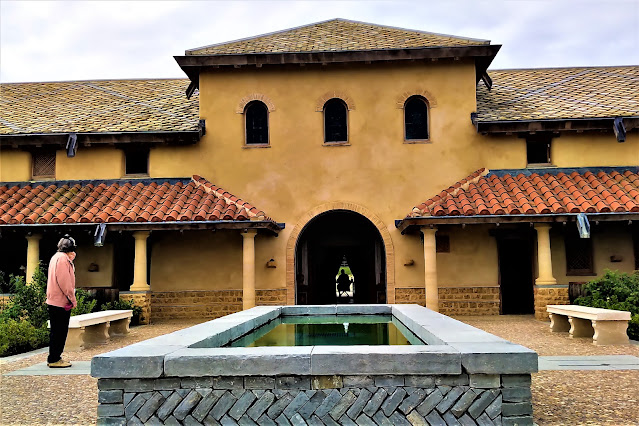
This evening, I am reporting on my visit earlier today to a meticulously reconstructed Roman Villa in Somerset, England. Funding for the project was provided by a South African billionaire. Specific features of the reconstruction project which is known as 'Villa Ventorum': Employed hundreds of architects, builders, archaelogists, mosaic makers, fresco painters and experts on ancient plumbing. The new build was built close to the remains of the original villa which dates from AD351. Incorporates the only working hypocaust system in Europe to create authentic Roman underfloor heating. Thne system also provides heating for the internal baths. Designed to appear to visitors as though still in use. Mosaics and frescoes have been made below the top standards of the time (e.g. Chedworth ) to reflect the social rank of the resident family. Incorporates a Roman 'fast food bar' along the lines of that found in Pompeii . (Core of above information sourced from the Times newspape...
Street decoration in York York is an ancient city in northern England. Here visitors can connect with the city's growth over the past 2000 years, from the Roman period then Viking, medieval and modern. However, this post places an emphasis on the Roman period. Roman York York was known as Eboracum. Consistent with other Roman forts the plan at York was based on a playing card design with strong external defences and a grid of streets inside. Hadrian visited in AD 120 in context of initiative to build his famous wall. Initially York was garrisoned by the Ninth Legion and subsequently the Sixth Legion. Roman HQ building The civilian section contained public buildings such as bath houses and temples plus fine houses for the wealthy. The Emperor, Septimus Severus used York as a base for military campaigns in the north during 208-211. In AD 306 the emperor Constantinus I died in York and his son Constantine the Great was acclaimed emperor by the army. R...


Comments
Post a Comment