Posts

Showing posts from April, 2023

Lacock Abbey:The birthplace of modern photography

Image
    Facade of Lacock Abbey This evening, I am reporting on Lacock Abbey in Wiltshire , England the birthplace of the film photography which was widely used until replaced by digital technology. Lacock Abbey is a mansion owned by Britain's National Trust. The architecture is an unusual blend of medieval and 19th century. In essence, the original 13th century home for Augustinian canonesses was disbanded by King Henry VIII in 1539 and then purchased by Sir William Sharington.John Ivory Talbot inherited the property in 1714 and over the succeeding 58 years remodeled the building and grounds.William Henry Fox Talbot and his family resided at the abbey in the early 1800s.In August 1835 Fox Talbot captured the first photographic negative which proved to be the foundation of modern photography.  Lacock Abbey in context of surrounding grounds Spring flowers at Lacock Abbey   Grounds at Lacock Abbey  Aspect of adjacent village Fox Talbot was a well educated and highly intelligent person wit

Avebury Prehistoric Site, England

Image
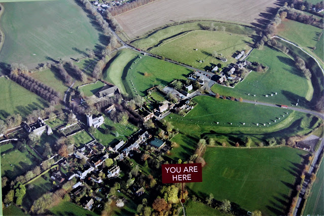
Here is my report of a recent visit to the famous Avebury prehistoric site in southern England.Location is about 25 miles north of Avebury's more famous 'sister' site of Stonehenge which in turn is 88 miles west of London. Here is an aerial view of the site today showing the site with encroachment of modern (and not so modern) housing and roads.  Here is an artist's impression of the site post construction, about 2500 BC. Here is an image illustrating the massive size of Avebury vs the much smaller Stonehenge site.The outer stone circle at Avebury is the largest prehistoric stone circle in the world.  Date of construction The site dates from around 2600 BC which was during the Neolithic period. The digging of the great ditch and building of the bank at Avebury henge was undertaken first. Around a century later standing stones in circles within the henge and two avenues running from it appeared.  View of ditch and stones. The people responsible for construction The Neo

Bekonscot Model Village, England

Image
    Today I am reporting on the oldest original model village in the world in the world It portrays aspects of England mostly dating from the 1930s. Bekonscot was created in the 1920s by a   Beaconsfield   resident, Roland Callingham (1881–1961), and opened to the public on 4 August 1929. Callingham, an accountant, developed the master plan for his miniature empire as an addition to his large back garden, drawing in help from his staff: the gardener, cook, maid and chauffeur. Together they developed the model landscape portraying rural England at the time. The   swimming pool   became the first "sea" and the undulating rockeries were built up as hills.     Bassett-Lowke, the large-scale model railway manufacturers, were commissioned to build an extensive   Gauge 1   railway network for the project. [ Callingham named the village   Bekonscot   after Beaconsfield and   Ascot, where he had lived previously. Bekonscot was not conceived as a commercial   visitor attraction   bu

Latimer, England

Image
This evening, I am reporting of today's trips around various sites in and around the English village of Latimer (pop 1000). Location is about 20 miles NW of London.   Classic English Cottage, Latimer, Buckinghamshire Classic English House, Latimer Boer War (1899-1902) memorial, Latimer  Former village pump at Latimer Inside St Mary Magdalene Church, Latimer  Tall trees in local woodland Bluebell Wood River Chess. Also general location of former Roman Villa. Latimer House, a former Victorian mansion and now a hotel. Cowslips     Mistletoe River Chess Marsh Marigold at Latimer House Carp and goldfish at Latimer House   Goldfinches  Grey squirrel     Parakeet at bird table. The ring-necked, or rose-ringed, parakeet is the UK's most abundant naturalised parrot. It became established in the wild in the 1970s after captive birds escaped or were released.This bird originates from a broad belt of tropical countryside stretching from west Africa to lowland India.  

Giant's Causeway, Ireland

Image
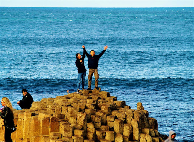
 Tonight, I am reporting on the Giant's Causeway in Northern Ireland .   This feature lies at the foot of basalt cliffs along the sea cost on the edge of the Antrim plateau. It is comprised of about 40,000 massive black basalt columns which protrude into the sea. The landscape was caused by volcanic activity during the Tertiary period of around 50-60 million years ago.More detailed information can be found here . This is a World Heritage site owned by the National Trust, a heritage organisation. Check website for access details. Location is about 60 miles north of Belfast, near Bushmills.   Here is a video clip.

Ceiriog Valley, Wales

Image
Tonight, I am reporting on the green and pleasant Ceiriog Valley in N.E. Wales. The video clip below speaks for itself. The district is very rural but only 10 miles from Llangollen and Chirk which has a castle. The English town of Oswestry is close by.  Other important visitor sites include: Pistyll Rhaedr waterfall in the Tanat Valley. The Pontcysyllte Aqueduct. The landscape includes distinctive, narrow drovers' roads and ancient layered hedges.  Here is a link to blog record of a hiking trip around the valley. 

Arbeia: Commanding Officer's House

Image
 This evening, I am reporting on the restored commanding officer's residence at the Roman fort known as Arbeia at the eastern end of Hadrian's Wall.  The video clip below provides an insight into what the interior may have looked like. Many years ago I had the opportunity to overnight at the property together with a group of re-enactment Roman soldiers who were marching along the line of Hadrian's Wall. More information on Arbeia This partly reconstructed fort is located at the eastern end of  Hadrian’s Wall, overlooking the mouth of the River Tyne in N.E. England. Key facts: Probably built around AD 161-180 to replace an earlier fort in the vicinity. Site extended from 1.7 to 2.1 hectares after AD 200. Rationale was to extend capacity as a supply base in support of strategy to conquer northern Britain. The site was extended to include 22 granaries, to hold vital food supplies for the troops. After abandonment of the northern campaign Arbeia acted as a supply base fo

Symonds Yat, England

Image
This evening, I am reporting on the magnificent vista at Symonds Yat which is located on the English side of the Anglo-Welsh border. Here is a beautiful green landscape through which winds the River Wye, Britain's fourth longest river which ultimately feeds into the River Severn ,the longest river in Britain.   The name Symonds Yat has two separate sources: Symonds is the name of a 17th century sheriff of Herefordshire whilst the 'yat' element derives from the old Scandinavian word for gate. The site is located about 25 miles west of the city of Gloucester. A nice spot for quite reflection!  

Cycle Hadrian's Wall Path, England

Image
  (Above image shows wildflowers at Grinsdale) This evening, I am reprising a cycle ride along a western section of Hadrian's Wall in northern England. Today was characterised by cloud, westerly winds and intermittent light rain .  Not ideal cycling conditions,but tomorrow is forecast to be worse! We departed our Carlisle lodgings after breakfast and then navigated out of the city, initially connecting with the River Eden and then west, following the line of Hadrian’s Wall out of Carlisle’s industrial area with initial stop at the village of Grinsdale where we visited the tiny church which has been decommissioned for worship purposes and is now for sale. River Eden at Grinsdale Grinsdale Church In contrast to sections of Hadrian’s Wall east of Carlisle, only traces of the Wall exist in the eastern section although some of the masonry from the Wall and fortifications  has been incorporated in churches which we visited. After continuing west for about an hour (into