Old Kilpatrick, Scotland
Introduction
This evening, I am posting information on Old Kilpatrick. This is a village community of 3200 which is situated on the north bank of the River Clyde. County is West Dunbartonshire, with village about 15 miles NW of Glasgow.
Erskine Bridge, River Clyde, Scotland
 .
.Information on Old Kilpatrick
The village sits in the shadow of the Erskine Bridge which was built in 1971 and spans the Clyde with a length of 4336 feet. There is a railway station shops, pubs and a church. Prior to the bridge a ferry operated between Old Kilpatrick and Erskine.
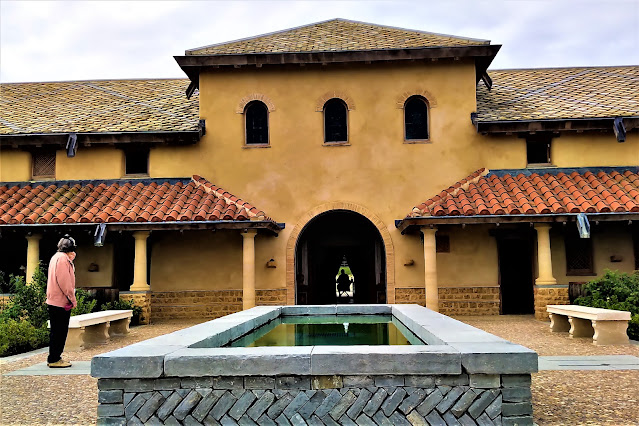
Old Kilpatrick was the site of a Roman Fort which formed part of the western end of the 2nd century AD Antonine Wall. The fort’s remains were discovered and excavated intermittently between 1790 and the 1920s. They are no longer visible. The fort extended to about four acres.
More information on Old Kilpatrick:
- Is a candidate for the birthplace of St Patrick in the 5th century although there is no compelling proof of the link. The name means ‘Patrick’s Church’.
- Is close to the principle road west to Loch Lomond whilst to the east is a major whisky distillery, Auchentoshan.
- Is situated on the bank of the Forth & Clyde Canal, which is principally a leisure facility today.
- Behind the village (north) are the Kilpatrick Hills, which were formed from volcanic lava flows some 340m years ago.
Kilpatrick Hills, Scotland

Old Kilpatrick, Scotland

Old Kilpatrick, Scotland

Landscape view of Old Kilpatrick

Old Kilpatrick War Memorial and Erskine Bridge

More information
Information on the Antonine Wall and many aspects of Scotland can be found in Visitors’ Guide to Scotland. The ISBN is 978-1-9161332-0-4. This is also available via Kindle.


Comments
Post a Comment